Many of you know about Google Maps, but how many of you really know how to master it? Besides the real facts that it offers street maps, route planner (for traveling by foot, car or bike), a locator for businesses around the world with user’s reviews and photos, satellite images and street views for most of the streets, it has some hidden features and capabilities too. That’s why, we are about to show some interesting Google Maps tips and tricks.
Use Google Maps Like a Pro
When traveling to a new city for various purposes, such as work or family trips, you need to know how to get to the established destination, without getting lost and losing a lot of time on the road. Some people who are not familiar with the new technology, choose to use traditional maps, which are very large and inconvenient, while others, who know how easy is to work with a mobile phone and a mapping service application, always resort to the most amazing one, known in all corners of the world, the Google Maps. If you read the entire article, you will find out how to ease the search through this application, by learning lots of tips and tricks that are extremely useful even for a professional user.
Save your home and work locations
Set up your home location on Google Maps to ease up your job when trying to create a new route for your well-deserved holiday. Furthermore, by adding the work address will simplify your future searches because from now on, you will only have to search using the terms “home” and “work”. Google’s intuitive interface will automatically display your locations as suggestions, so that you won’t have to type the full address anymore. In order to pin home and work addresses on the map, just follow this simple guide: Another nice thing that will happen when you do this is that when browsing Google Maps you will actually see two pins on the map, each one representing your home and work locations. To add home and work locations using the new Google Maps layout, just follow the below steps: Also, you can always select the “Gear” button from the upper right-side of the page and select “My places” which will transfer you to the classic Google Maps interface. If you are using the mobile app, just open the Google Maps application and go to the upper left-side (or bottom-left on Android) and press on the little button. A menu should drop down and choose from it the “My places” option. If there aren’t already set up, add the correct address by tapping on each one and writing the location’s address.
Share your maps
Did you find a new place you want to visit and you want to share it with your family, but you don’t know how to do it? It was never simpler, because with Google Maps, when you use the map the URL address automatically changes. So, you will only have to double click in the address bar of your favorite web browser, copy the address by simultaneously clicking CTRL+C (or right-click in the address bar, press “Select all” and right-click again and select “Copy”) and paste it by pressing CTRL+V wherever you want. More details here. It’s possible to send it by email, through your favorite messenger client or via the online social networks, like Google+, Facebook and Twitter, and the person that receives the location can immediately see the map.
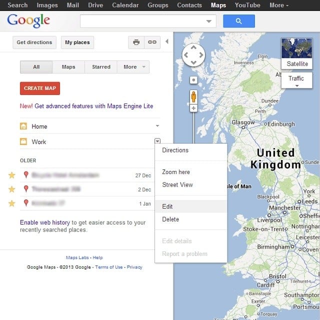
Star your favorite places
In the past few weeks Google Maps was changed to its new layout which also permits users to add their favorite places on the map. All users have to do is to search the location by address and click on the star-shaped button, which will add a pin to the specified location. To view the selected place, look on the map for yellow stars, because this feature makes your selection’s location always viewable, even from the big picture.
Use the traffic layer over your maps
Google Maps has an extraordinary feature that enables you to identify the most convenient route for getting to your established destination, based on the traffic conditions in that particular area. For each kind of traffic condition, this application has a certain color that shows you the speed of traffic. For example, the green color is used for highways when the speed is normal and, when the roads become red, it means that the traffic speed is slow. Note that the redder it gets, the slower the speed is. If you see the gray color, then no data is available. Follow the next steps in order to discover how to activate the traffic layer on your own computer:
Use Google Maps for getting public transit directions
Did you know that Google Maps can serve as a route planner for your trips made with public transportation? Yes, it can really plan your trip if you intend using a train, a bus or a plane and actually it’s very easy to do it. After choosing your location and destination, just choose the train-shaped or plane-shaped button at the means of transportation menu and multiple routes will appear. Just choose the one that fits your needs and enjoy your time that was saved by not using extra websites which would have been more complex. It’s important to know that this feature is not (yet) available worldwide, but only for the major cities from USA and from few selected countries across the world.
Offline Google Maps
In case you travel to a place where there is no Internet connection or if you go to a new place where it takes some time to get a new mobile connection, an offline map would really come in handy. A couple of months ago Google implemented a feature which permits users to download a part of the map on their mobile device which can be used later, without the need of an Internet connection. If you are using the version 6.14 or below of Google Maps, follow the next simple guide: The app will show the estimated size of the download content and permits up to 6 maps to be downloaded as long as you have sufficient storage space. Approximately two months ago a new version of this useful app appeared and new interface was added along with improved capabilities and features. To download a map with this application, just follow the next steps: Also, after big complaints from users regarding the lack of a real option to offline mapping, developers added the option “Make this map area available offline” to its search card in order to make its users happy.
Set your current location on Google Maps
In order to provide the best results when searching for a new route, Google Maps provides your current location based on your computer’s IP address. In case the pin which shows your location on the map is misplaced, you can easily specify the correct address by simply clicking the correction button. Be aware, that this is only available on the classic version and not on the new and refurbished interface of Google Maps. On the new version your location will be automatically detected and if it’s incorrectly mapped, you just have to click on the gear option (which is placed on the upper-right of the screen), click on “Search settings”. Then, just press the “Location” button to update your location. On the mobile application users can simply press the upper right-side button which looks like an aim to automatically update their location.
Search for places
If you are planning to take your lunch at a Chinese or Thai restaurant and you don’t know any near to your location, Google Maps comes in help. Simply type in the search box “Chinese restaurant, your location” and multiple results will directly appear in the results list.
Explore businesses
Besides classic searching, you can always explore different recommendations when using the new Google Maps (version 7). All you have to do is to tap and write into the search box the word “Explore” and a new page will appear which has a menu with five categories:
Eat Drink Shop Play Sleep
From here, just browse until you get what you’re looking for.
Get more details on the move
After you searched and chose a business using a smartphone, swipe up and down to see the available information about the place. If that one doesn’t please you, swipe left or right to go to the next business that fulfills your requirements.
Zooming in Mobile app
The Google Maps application for Android and iOS devices it’s a great way for somebody to use maps. Almost every time when you have to plan a route or search for a local business, you have to zoom in or out on the map. That’s why it’s very important to learn how to do it right when using mobile devices. Besides pinching the screen, users can double tap on the map and scroll-up to zoom in or scroll-down to zoom out.
Warp to Street View
Street View can be sometimes tricky to access, especially when you are on mobile. All users have to do is press and hold the map until the pin appears in that particular location. Tap on it to enjoy other features, like getting directions from your place to there, see Street View or share location via text message or email.
Leave ratings and reviews
It was never simpler to leave ratings and reviews for businesses using the Google Maps application for mobile devices. This is a good way to offer other users a good and reliable opinion about the place. To do this, be sure that you are already signed in Google Maps before making a search. After, select the desired business and pull up its information sheet, search for “Rate and Review” and press on it. Rate the quality of the restaurant by setting the number of stars and writing a review, so that other users can visualize that place from your eyes.
Navigation and Step-by-Step directions
It’s possible to use Google Maps to direct users to different locations in real-time. One has to search for a place and access its information sheet where they have to select the “Directions” button. Furthermore, it can show the next steps that have to be made in order to reach the destination, by simply swiping to the left the top bar.
Use Mashups
Google permits developers to mix different data with Google Maps in order to create a better relation between the actual information and the location where it took place. That’s why, users can find some unusual, but in the same time cool and handy maps mashups like the one that spots the potholes (Pothole Season) or the one that helps you find a hotel nearby your desired location (Hotel Finder).
Create your own maps
You heard it very well, it’s possible to create a unique map that can be shared publicly or only with the ones you know. It’s possible to add different figures, shapes, flags, layers and much more by simply going the “My places” section and selecting the “Create map” option. Also, even if it’s a beta version, Maps Engine Lite it’s a Google service which represents the next step into the future of creating custom maps.
Location without a GPS connection
Thanks to its great technology, Google Maps can locate your current location without having access to a GPS connection by triangulating the phone’s signal from the nearby towers. To learn and understand more about this phenomenon, Google created the video above, where they explain how everything actually works.
Edit locations
If you are very sure that something is wrong with your house location or that the grocery store is misplaced, you can edit the map and let Google know that changes have to be made. For example, in order to correct the mistakes that may have appeared with the location of your favorite convenient store, follow the next steps:
Other Google Maps tools
Also, there are a lot of different apps and extensions for browsers which use Google Maps in order to locate different things. We think that the following three ones are ones of the best plug-ins which everybody should use: